India: East (Nelles Map) Map – Folded Map, 6 Jan. 2011
Product ID: 62123645
Buy anything from 5,000+ international stores. One checkout price. No surprise fees. Join 2M+ shoppers on Desertcart.
Desertcart purchases this item on your behalf and handles shipping, customs, and support to Australia.
Full description not available
K**!
You'd have to go a long way to find a better map of this area.
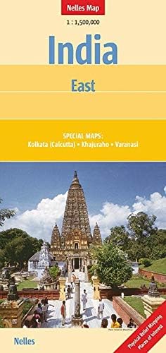
A good, double-sided map covering a wide area southwards from Nepal via Lucknow & Kanpur, Allahabad and Varanasi, Jabalpur, Raipur & Kolkata right down to Bhubaneshwar and Visakhapatnam. There are separate maps of central Kolkata and Varanasi, and one of the groups of temples at Khajuraho.The map uses physical relief mapping, so you can more easily estimate heights of locations and regions. It includes international and state boundaries, railways, airports and main roads. It claims to show minor roads and cart tracks too, but I have yet to test the accuracy of these!Places of interest, archaeological sites and national parks are clearly indicated.Road numbers are shown for main highways. Distances in kilometres are also shown, although volume of traffic and unpredictable road surfaces everywhere in India make these relatively meaningless!Having used other maps of India, as well as Nelles' ones of other parts of the country, I believe Nelles to be the most accurate and easy to use. They've also proved to be fairly resilient to repeated unfolding and re-folding, although a varnished or plasticized surface would be a great benefit to make them a bit more sturdy and longer lasting.On balance, however, this is an excellent map that's ideal both for planning ahead and, on the day, for showing drivers the route to follow.
C**D
India Nelles maps
I have four maps which cover most, if not all, of India. They show all I need to know to plan my trip: places of interest, railway lines, all without too much detail. Guides can take over for the finer details. I am very pleased with them.
H**D
Excellent map
Perfect for travelling in this area of India.
G**H
Five Stars
An excellent map with plentiful information and detail.
Trustpilot
1 month ago
3 weeks ago